
The next stop is Rice Knob. We drove back to Craven Gap which is where the trail head is. I wanted to see if it lived up to the billing that Scott had been raving about. I knew Rice Knob was a bushwhack off the Mountains to Sea Trail. What I did not appreciate was how steep it was. Scott had already done the bushwhack twice before and he was looking for the place on the trail where he started to the summit off-trail. The trail had been pretty flat for the better part of a kilometer. Somewhere between the ¾ and 1 kilometer point – we went off trail and used our GPS to find the ridge line.
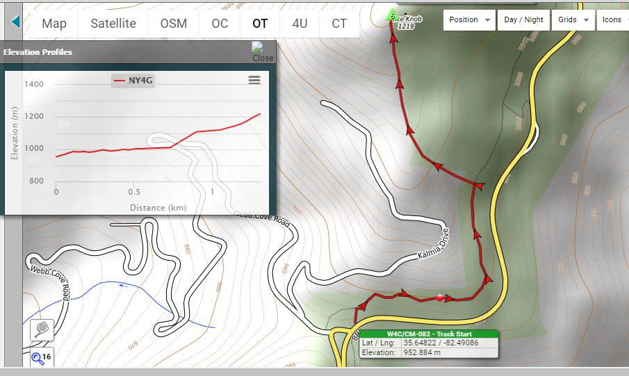
There are several pricey homes to our left and we stayed clear of the backyards of these homes. From the start of the bushwhack – it was steep. We had 500 plus meters of horizontal with 200 meters of vertical. There were three sections, the first one was steep, the second is on the shallower ridge, and the third is the final assault to the summit. From 728m to 895m or so, it climbed 100m in 165m – 66% grade. It was a relief to find the shallower ridge. It was pretty flat for 150m. We had just shy of 200m to the top. It was visually very steep. We had to climb another 190m – so it was near a whopping 90% grade. I am very unstable on my feet going down and so I dreaded the eventual trip down this mountain. The peak was very small and narrow and Scott and I were separated by about 25 meters when we set up our radios. We made our usual radio contacts. It was cold and windy but not as windy as Lane Pinnacle. Though it was in the 50s in the valley, up on the peaks it was in the mid-thirties – Fahrenheit, that is.
The time came for the dreaded hike down. It was just a matter of committing to it and setting one foot in front of the other. We finally made it down to the trail – and I thought “What a sight for sore eyes”. We hiked the remaining kilometer or so on relatively flat ground back to car.
Scott drove me to the summit of Peach Knob just a few minutes away which is at the site of a communications tower. Scott drove off and called me on the 2 meter hand held transceiver to score a chase. It took me all of 5 minutes to set up and another 10 minutes to make contacts with my chasers. Radio interference from the tower cut me short – but the required contacts (four at least) had been made to score the mountain.
No comments:
Post a Comment