Monday, December 31, 2018

SOTA End of Year 2018 Summary

Chaser Points - 465 - Reached #25 on the W4C All Time Chaser list (tied with KF4BY), and 9th for 2018 which is not too shabby considering I only started in late October.  The top 7 surpassed 1000 pts in 1 year with N4EX leading the pack by a wide margin.


Activator Points - 133 - with 14 Summits Activated, climbing up #19 in the W4C all-time list


For 2018, Patrick led the pack with 76 activations - which is more than 1 per week.  I climbed to number 11 in 2018 (just for the year).   Hopefully I stay healthy and put forth a good effort in 2019 - the clock starts tomorrow.


Saturday, December 29, 2018

Link Dipole Project

I wanted to make a link dipole that I can take on SOTA activations.  I wanted it to be light.  To that end I made some wire winders (17g)  that are less than half the weight of the SOTABeams plastic wire winders (37g).  The winders are made from Spanish Cedar.   The antenna (without the feedline) comes in at 144g.  The antenna covers 4 bands 60-40-30-20m bands.  This version is without the 60m add-on. This can be compared to:

LNR EFHW Trail Friendly 40-20-10 at 182g
LNR MTR 40-30-20 at 200g

The 60m add on only adds 13g for the additional 10 feet of wire per leg. Guy rope would add additional grams.


The version above has the 60m links added plus some guy rope.

W4C/WM-064 Satulah Mountain

Satulah Mountain is in the middle of Highlands NC and the summit itself has a home amongs the multitude of upscale homes in the community.  The hike itself is about 1.1 miles with about 600 feet of elevation gain.  We parked our vehicles in downtown Highlands and proceeded on the hike up Satulah Road

The hike was punctuated with views of Whiteside Mountain and many beautiful homes.


There were many signs prohibiting unauthorized vehicles from going up the road to the summit as shown by signs like the one above - though it did say "hikers welcome".


I set up the station at a rock outcrop - conveniently like a table 


The LNR MTR on the mast above

I did have one summit to summit contact with K7MK  who was on W7I/SR-167


Scott operating across the cul-de-sac at the summit.

View of the summit we just hiked.


My QSOs as displayed on the SOTA Mapping tool

W4C/WM-033 Shortoff Mountain - 8 Pts plus 3 Pts Bonus

We were at the same trailhead at coordinates 35 deg 6.2749 min North and 83 deg 12.2470 West when we activated Panther Mtn.   The trailhead has the title Yellow Mountain Trail and is the same trail that proceeds to Yellow Mountain which is 5 miles away.   The Yellow Mtn hike is longer as Shortoff summit is but a stop-over to Yellow Mountain.   The hike itself is some 1.8 miles.  The GPS track for the hike is shown below:


The hike has about 850 feet of elevation gain over teh 1.8 miles and is mostly over the ridge line between Cole Mtn and Shortoff.   The ascending parts are the first and last third of the hike and culminates in switchbacks to the summit.  The summit elevation is 5018 feet.


Upon reaching the summit, KW4JM (Scott) and I setup in the generous flat portion with plenty of room for antennas.   Scott used a tree limb as per his usual practice while I used the SOTABeams 10m mast.   This time I brought the MTR 3 band EFHW from LNR as I was using the K1 for this activation.  A pic of the deployed antenna above with a SOTA flag - of course you can't see the wire.


Above is the image of my mountain top station.


Scott - happy as a clam - working his pileup.  He started on 20m and I started on 40m.


A couple of hikers on their way to Yellow Mountain.  They really appreciated what we are doing and thought it was "cool".  Scott kept our visitors entertained.

Operating at the Summit


THANK YOU - CHASERS


Friday, December 21, 2018

W4C/WM-060 First Time Activation of Panther Mountain

We did a first time activation of the summit of Panther Mountain - 4600 feet above sea level. My hiking companions were Patrick KI4SVM and Scott KW4JM. Patrick is the Manager of the W4C Association for Summits on the Air (aka SOTA - a program for radio amateurs who love the great outdoors and making radio contacts initiated in the UK). Our hike started at a trailhead near the North Carolina town of Cashiers. We followed the forest service road which descended into the creek bed - about 650 feet then bushwacked up the mountain first by ascending the fall line towards the ridge, then climbing along the backbone of the ridge to the summit. we had to gain another 1000 feet of elevation from 3656 feet to the summit elevation of 4616 feet. The roundtrip hike was a total of about 7 miles with about 1600 feet of elevation we had to negotiate. Our hike down was less steep but longer.
At the summit we were rewarded by amazing views and warm weather (in the 50s with little wind). I settled down into my operating position, erected my antenna and started making contacts. Almost immediately a California station called. After a few more contacts I heard what sounded like a ZL prefix in Morse. I listened to it again and copied ZL1BYG. I sent his call back to confirm ZL1BYG? and he returned ZL1BYZ and gave me a signal report that I was very weak. That is a New Zealand station!! - How cool is that?!. We exchanged signal reports and closed the exchange. That is a first for me to bag a station from clear around the globe with my little radio transmitting a puny signal.


Here Patrick KI4SVM (red shirt) and I were trudging in the snow on the Forest Service trail


Patrick KI4SVM and I at the summit - photo by Scott KW4JM


Scott's HB1B doing yeoman's duty


My KX3 and my HT


That is the beast we have to slay (Panther Mtn) - taken from the trail


Scott KW4JM operating at the summit


Patrick KI4SVM is operating in comfort


GPS track of our hike in

Hiking back to the vehicles - all uphill - about 650 feet of elevation gain 


Thanks for reading this through the end


Friday, December 14, 2018

Antenna Testing Using WSPR - 20m Hex Vs 30m Dipole - Part 2

14MHz Results -200mW TX 


Results - with 24 hours of data.   A lot more European stations reporting than the 30m dipole results (below). The back side of the beam is much weaker as can be expected.  Nighttime performance drops off more dramatically than 30m dipole.  Signal was received as far away as Reunion Island on the eastern side of Madagascar some 15622 km away which is also within the beam spread.  The comparative results comparing 24 hour periods shown above.

30m Results Below For Comparison


Wednesday, December 12, 2018

Antenna Comparison Testing Using WSPR - PART 1 - 30m Standard

Instead of using and setting up my shack rigs for WSPR, I have instead a dedicated WSPR transmitter from SOTABeams as can be seen in the picture below:


The setup is super light and consists of a WSPRlite classic box which uses 5V (USB) power and transmits at 200 mW.   The other box on the left is a 5V signal conditioner with 12V input.  This insures that the input from a switching power supply is clean (no ripples).  Here I am using a 12V SLA battery which should be clean to begin with but still needs to be stepped down to 5V.  This setup is light enough that it can be carried into the field, even on a SOTA expedition.  Input can also be from a USB charging station, like those sold to recharge phones and tablets.

Objectives:

(1) Establish a standard  - for 30m - a 30m dipole sloper, 40m - a 40 meter dipole inverted V, 20m - hexbeam at a certain fixed azimuth
(2) Compare that standard to my SOTA antennas - the EFHW Trail Friendly 40-20-10,  the EF MTR - in their normal deployed position - typically inverted L or inverted V

Here is an image of the placement of the antenna on the property.  So the broadside for maximum gain is approximately at 55 degrees azimuth from true north.  There is a northwest null point with some omni gain in the direction of the slope down.


Here are the far field plots according to EZNEC


The model predictions maximum gain in the most preferred azimuth of 55 to be 7.26 dBi.   Let's see if the model predictions hold up against the real world.

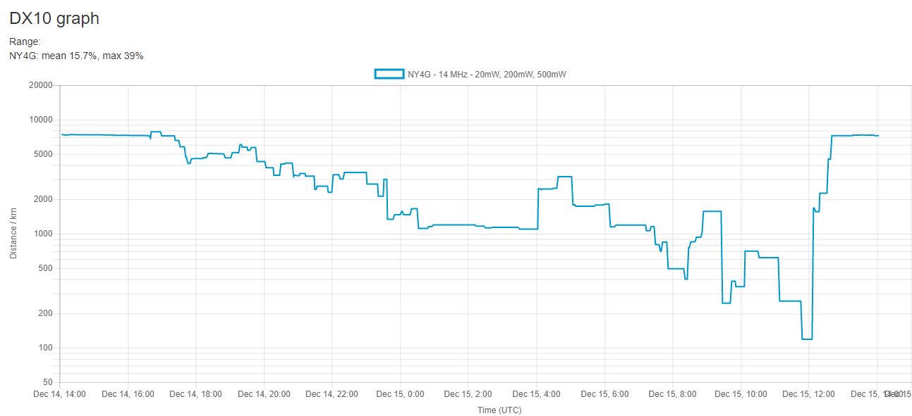
First results - Standard for 30m.  The first image is a great circle map with receiving stations plotted.   The second image is a table of distances as a function of UTC time.   As can be expected, the night time distances are shorter - with a second peak near 0500 UTC that is not as far as the daytime peak at 2000 UTC.  Note that the Y scale is logarithmic and not linear.  In this manner - daytime ionization greatly enhances the ability of the upper ionosphere to be reflective - just like 20m.   But like 40m, the band can still be active even for shorter distances at night.  So the best time for a European contact is between 2000 and 2200 UTC or about 3 PM local time. 

Note that as to be expected - the signal are received by European stations and west African stations in the Azores.   In the sloper direction, there is a signal received as far as Antartica (not shown on the dot plot).   The table below shows the maximum distance stations and their respective grid squares with an average distance of 7731 km.   The performance is marginal for picking up western states as the far west states hear me at -19 SNR - or about just as good (or as bad) as the European stations.  The best stations which come in as high as 4 SNR is in the W2 calling region.  So for SOTA chasing, this appear to be as good as it will get with a dipole in terms of antenna orientation and height above ground.  The question becomes - can I hear a European or western state with their 5W signal CW when they can hear my WSPR signal at 0.2W at -19 SNR.   Now if they were transmitting FT8, there is a chance I can hear them, but it appears, that for SOTA chasing European activators, my best chance is with a gain antenna - as a minimum - 2 element yagi - with the ability to point and shoot.

It should also be noted -  the model predictions are entirely consistent with EZNEC 5.0 predictions.

NEXT - 20 meter 2 element yagi with a 55 degree azimuth