Friday, March 15, 2019

W4C/WM-010 Steestachee and W4C/WM-004 Waterrock Knob

Proceeding from Mt. Hardy on March 13, I arrived at the Grassy Ridge Mine Overlook on the Blue Ridge Parkway.   I read the notes from Dean K2JB and Patrick KI4SVM – with emphasis on keeping an eye on the fence line on the right for navigation for summiting Steestachee Bald W4C/WM-010.   I got on the Mountains to Sea Trail (MST) for about 50 meters and began the bush-whack after I passed the cut-up dead fall which crossed the trail.  I saw the fence line that Dean mentioned and kept it within eyesight as I trudged on up the steep summit.   There was no definable ridge so this fence line was important to keep an eye on.   I dodged many fallen trees on the way up.  Being leafless, the hardwood thicket was easy enough to bust through.   Only 750 meters or so to the summit and before long I was there.  I found a small clearing at the summit to set up my radio station.   The climate was pretty temperate and comfortable and I settled into my sweep of the bands from 20m to 30m, then 40m and 60m and generated a lot of QSOs.  I did get a summit-to-summit call with AC1Z who was on W1/HA-010 which was a nice bonus.   Time to head back down the hill and go on to Waterrock Knob.   I took a track favoring ease of footing and lost track of the fence line.  I did not realize that I was veering away from the fence line track.   I should have generated more way points on the way up.   I only had two way points – one half way and one back at the car.    I tried to navigate to the most recent way point and realized that it was to the left of me and almost behind me.   I knew I had to scoot sideways to recover to the fence line.   My footing was either soft or hard depending on whether I was stepping on rocks or fallen leaves.   I kept on sliding over to the left as I carefully and slowly made my way down.   Soon I found out that I had to climb out of the hole I was in back to car for about 200 meters to the left.   I never did see the fence line and just saw my truck above me about 50 meters away.  It was a relief to hear the sound of cars passing on the Blue Ridge Parkway and seeing my truck again.


The start of the hike on the MST.  There i a cut up log about 50 meters away where the bushwhack starts


A look back to the truck as I got started


Summit is heavily forested but there is a good cell signal


The summit is not that big


The overlook where the truck was parked


Getting ready to go to Waterrock Knob


I got in the car and noticed the soreness of my quads from the effort of the bush-whack.  I proceeded on to Waterrock Knob W4C/WM-004, another 10 pointer.   This was a civilized hike with a partially paved walk up of 800 meters or so and 138 meters of vertical.   It was short but steep with large rocks as stepping stones.  With my sore quads, I slowly made my way up the trail.   Soon I was on a familiar summit.  Scott KW4JM and I had been here the year before and this was one of my first few summits.   I recognized the trees and the bench that had been there previously.   Set-up now is second nature and I was on the air in just a few minutes, swept the bands as usual.   No summit-to-summit QSO’s while on the summit this time.   After the sweep of the bands, it was time to head back down and savor the day.   It was still a pretty good day with 2 out of 3 summits successfully activated.   I was both tired and hungry.


View of the parking lot from the summit


Mount Hardy Fail

It was March 13 and still week 9.   It was bound to happen sooner or later.   It was perhaps my inexperience, or maybe just bad luck, or just maybe it was the right thing to do under the circumstances.   I came within 750 meters in distance and within 100m of vertical to the summit of Mt. Hardy when I decided to abandon and back track my way to the trail head.  I followed what I thought was the main trail of the Mountains to Sea Trail but other than the blue blaze at the trail entrance, there were no other signs that this was the right trail.   It seemed to follow the published track by KI4SVM in terms of direction but the expected feeder trail to the ridge line of Mt. Hardy did not turn out to be the right one.   I followed what I thought was a lightly treaded trail to the right as expected.    The tread got lighter and lighter until it vanished.  It became a potential bushwhack as the summit is clearly visible from my vantage point.   A bush whack at this point would eat up a lot of time and energy which put the subsequent two planned summits for the day in jeopardy.  Also I could get lost in this vast wilderness and take the entire day to find my way back.   I thought that the better part of valor and the more sensible one is to abandon, back track to the trail head and proceed to the other summits.   I had 6 kilometers invested into the hike to be invested as exercise – live and summit hike Mt. Hardy another day.

This is a quote from Mountain Goat Joel Shannon KC4WZB “This is an easy hike to get confused on. I knew to look for the side trail to the summit, saw one, checked my GPS, it said I wasn't there yet so I kept going, just like many others had. Had to backtrack 0.10 mile, but got on the right track. There is no cell coverage at all on this summit. SMS did not work and without hunt and pounce, RBN, or APRS it might be a bust anyway. Several places to get off track on this one. K2JB Jimmy Dean Blair said this one was a summit that made him decide to not activate alone if there's not a really good trail. I barely got 4 contacts and had to come down in the pouring rain when I did this one. Several others have had a tough time on this one. Let me know if you want to do this one again and I would be glad to tag along. 73-KC4WZB”


The trail head across the street from Rough Butt Bald Overlook


Rough Butt Bald Overlook Parking - 


One of the many small streams to cross along this trail


Another stream to cross


So close yet so far - I was within 750m and 100m of vertical at this point on the trail


Distant and nearby peaks as identified by Peakfinder


Tuesday, March 12, 2019

Max Patch Mountain and Snowbird Mountain Doubleheader

It was Monday morning March 11, after the “spring forward” time change.   Feeling a bit disconnected and lacking the hour of sleep, I woke up later than usual and forgot to put out alerts for the day’s activations.  It was a two hour drive from my house to the trailhead in the mountains near the TN/NC line via Interstate-40.  Dave came to my house at 7:00 AM on time for our departure and we rode together.   I noticed that cell service was very spotty as we made our way through the twisty mountain roads.   Realizing we still needed to put out alerts, I tried using the SOTAgoat iPhone app to do it via the internet – no luck.   I texted Scott to do it for us.   The text made it through and he gladly obliged.   Thank you Scott.

We made it to the GPS coordinates for the trail head on Max Patch Road without any issues.   I looked at the map and the GPS track.   The trail starts on the other side of the road.   After a little bit of hunting, we found the white blazes of the AT and we were on our way.   The weather was perfect – almost spring like, in the low fifties and calm winds.   The trail was mostly dirt – packed down North Carolina clay and loam, slightly moist from the recent rains.  Our footing was pretty solid the whole time.  We had a great view of the right side of the ridge as we were going up.   Soon we were above the tree line as we made our way through the 1 kilometer or so hike up to the summit.   With clear skies, the view on the right side of Max Patch ridge was fantastic.   Dave and I made a left turn into a long set of stairs made from logs and dirt and climbed another 100 meters or so of vertical before making it onto the final ridge line to the summit.   It flattened out a bit on that final approach and by now we had spectacular views of both sides of the ridge and we had just 200 meters to go.   We saw the summit from there was completely devoid of trees – a true bald summit.  We approached the US Geological Survey summit marker and took photos of it.   We gazed at the views in wonderment.   Wow – a full 360 degree panorama of the surrounding mountains and hills.   We started to set up and 3 hikers approached us from the east of the ridge.   They were hiking 20 miles from Hot Springs North Carolina and they have been on the AT for two days camping and hiking.   Their names are Sheila, Andrew and Christine.    Sheila and Andrew are visitors from Canada.   Christine works for an outfitter as a guide and is very familiar with the North Carolina Mountains.    I spoke to them that Dave and I were radio amateurs and that we were summit activators in the SOTA Program.   They asked what that was all about and spent about the next 10 minutes explaining about activators, chasers, and the points system, who gets credit and how.  I told them that if they stayed for a few minutes, and it takes us no time at all to set up and soon they can hear me making contacts with our chasers.  They stayed a bit longer – and as soon as I started calling “CQ” in Morse, the callers started piling in.


Stairs leading up to the ridge


Summit marker placed by the USGS


Sheila and Andrew - visitors from Canada and Christine their mountain hiking guide 


Makeshift shelter at the summit of Snowbird Mountain

About noon time, we broke setup and headed back down to the trail head so we can go on our next activation – Snowbird Mountain, about an hour’s drive.   It is only 10 miles away “as the crow flies”.
Suddenly, the weather changed as we were driving to Snowbird.   Rain started falling – a bit of a drizzle at first and then more steady.   As soon as we got off Interstate 40, we proceeded on gravel roads mostly.  With about 5 km to go – we were still only at 700 meters elevation.   This only means one thing – over the next 5 km miles we will gain close to 600 meters of vertical ascent.  We were hoping the weather would get better or at least stay as a light rain.   When we reached the summit, we arrived at a VORTAC station with a large wood fence surrounding it.  Dave came up with the idea and said “I have a tarp.   We can string it up along the fence line for shelter and we can operate from there”.   We quickly set up the make-shift shelter, using the highest fence posts for support.  Dave extended his trekking poles and placed it inside the grommets to give one side some height.    We pushed up the mast and erected an inverted V antenna from the end fed wire that we typically use and we are good to go.   Cell service was good, so no problem getting a spot out.   I said to Dave “Let’s take turns.   I will go on 20m – get at least the required number of callers, then you take it over from there on 40m” as I started to call “CQ” on the KX2 using only the internal batteries.  It worked out as planned and we had more callers that wanted to call us but with the wind kicking up, it was hard to hear the callers because of the fluttering sound of the tarp being buffeted by the wind.  So I announced in Morse “QRT, QRT, high winds and rain, 73 73”.  It was a successful activation day for both summits and both of us were delighted.   I said, “One more thing remains, making it down safely down this mountain on the narrow mountain road in the wet.”  We took our time coming down, being careful not to slip in the wet switchbacks.   Before too long – we were on Interstate 40 on the way home.


Friday, March 8, 2019

Activation of Mt. Mitchell W4C/CM-001 and Green Knob W4C/CM-020

The activations took place on March 7, 2019.

The Craggy Gardens section of the Blue Ridge Parkway near Asheville had been closed all winter.  The easy access to Mount Mitchell is through this section of the Parkway near Asheville.   I would have to enter the Parkway from Marion NC through the torturous and slow NC80.   Weather conditions somewhat dictate the order I do the activations.   I would have to save Mt. Mitchell for the warmest temperature during the day, knowing it would be coldest at that very high elevation close to 2000 meters.

The plan played out perfectly as planned.   Dave KE4EA and I headed out just after breakfast from the restaurant we meet at for an early morning bible study with a group of men from our church.  With Dave “riding shotgun” in the truck the two hour plus trip up windy NC80 did not feel so long with the conversation and banter on the way up.   The weather turned out better than expected with really calm winds, sunny and temperatures in the low thirties on the Blue Ridge Parkway.   We did not have any trouble finding the Green Knob trailhead on the Mountains to Sea Trail using the instructions from KI4SVM.   We were up on the summit after 39 minutes.  Dave set up his station near the fire tower and I set up about 50m away on the trail.   It was kind of tight, but the 40 foot end feds we used were just perfect for such conditions.  Dave and I swept the bands from 60m to 20m and made contacts with our chasers.  First contact was with another activator on a summit, NM5S, who was on summit W5N/PW-027 in New Mexico.  I even got a call from chaser Jorge EA2LU, from Spain.  We were under very pleasant weather conditions on the summit on Green Knob and we savored the moments there.   Soon it was time to pack up and head to Mt. Mitchell.   We made it down in about 25 minutes and after the 9 mile drive – we were up on the summit of Mt. Mitchell.

We were not alone on the summit and there were a few intrepid visitors.   A group of four college age visitors from New Hampshire were fascinated with what we were about to do.   I told them that I had a bunch of chasers anticipating our activation and that in 5 minutes – a small pileup will ensue.   They waited patiently as I sent out my spot.   I started calling CQ, and after the first CQ call, mayhem ensued on the 40m band as eager chasers wanted to make contact.   I translated to the visitors the call signs and where they were from as I dispatched each contact one by one.  They said – “Wow, this is s-o-o cool!”  I gave them the web address of the SOTA website and my blog since they were interested about knowing more about SOTA.  The balmy, windless weather changed all of a sudden and turned sharply colder with intermittent gusts of wind.  Dave and I decided to pack up as our hands started to feel really cold.   I missed the text from John Paul AB4PP wanting to have a contact on 60m as Dave and I proceeded to travel back home to Travelers Rest SC.   Dave and I remarked that it had been a good day to be out on the mountains today.


QSOs from Green Knob CM-020


Mt. Mitchell QSOs


Solo Activation of Big Bald W4C/WM-046

I did Bald Knob, as a solo activation, on Tuesday March 5.   It is a nice gentle hike with 200m (660 feet) elevation gain over 3.2 km (2 miles) or roughly 6% grade.   The trail is a gated forest road on Explorer Road just off NC215 and a couple of miles south of the Blue Ridge Parkway.   The upper portion is grassy while the lower portion has heavy equipment tracks all over.  I averaged just over 30m/mi on the way up and about 27m/mi on the way down.  It was cold but not bitterly so – low thirties with about 10 mph winds.  The summit had a clearing that was large.   I decided to use my trekking staff as a mast holder and it worked perfectly using just 3 guy ropes.  I swept the bands as usual and made 29 contacts.   I was able to make contact with three other summits – George KX0R who was on W0C/FR-107 in Colorado, Keith KR7RK who was on W7A/PE-068 in Arizona, and John K1JD who was on W5N/SI-017 in New Mexico plus a DX call from chaser EA2LU from Spain.  It was a very productive activation.


Friday, March 1, 2019

High Rock Activation W4T/SU-010

The activation took place on February 27.   It was still week 9 and I needed to make up for not having activated Grassy Ridge Bald.   I still had a couple of sunny days left in the week before the rains come back and fortunately Dave, KE4EA, was available as a hiking companion.   The trailhead for High Rock W4T/SU-024 is accessible from Interstate 26 near the TN/NC line at Sam’s Gap.   Just a few minutes from Sam’s Gap is the Ski Resort at Big Bald W4T/SU-010.  It would be an extra bonus if we can make it into a double.   When we left my house in Travelers Rest SC, it was raining steadily.   The rain abated as we travelled up to North Carolina.   When we arrived at Sam’s Gap near the TN/NC line, there was still a hint of a drizzle which quickly gave way to partly cloudy skies as we made it up the Appalachian Trail (AT).   The AT crosses over the summit of High Rock.   The weather was ideal for hiking – temperature in the low 50s, calm winds.  The trail was especially well groomed.  We ran into a few hikers “thru hiking” the entire AT.  We met a Mr. LaPierre who was “thru hiking” the entire length of the AT (2200 miles) for the third time.  We finally made it to the summit about noon.  Dave and I set up our stations and we started making contacts.   I even got a chaser from Belgium ON4VT.   Dave is now comfortable again with CW and is making contacts with hardly any trouble at all.  After we had swept the bands and the chasers have “dried up”, we made it back down the mountain and proceeded to Big Bald.   We stopped at the gated guard shack for the moment of truth.   The guard asked us concerning our business there.   I said we wanted to visit the ski resort.   The guard said that the ski resort is closed and he turned us away.   The desired “double” was not to be this day.  But at least, I made up for not having activated Grassy Ridge Bald.


Grassy Ridge Bald Busted Triple

This all took place on February 25.   Grassy Ridge Bald shares the same trail head as Roan High Knob.  Getting to the Grassy Ridge Bald trail head is a two hour drive from my house to Carvers Gap.  I left my house at 6:45 AM and went to the old law office of Scott, in Asheville (about halfway) to meet and carpool up to Carvers Gap.   We arrived at Carvers Gap about 9 AM.  We got out of the car and the wind was a steady 25mph or so with higher gusts.   We took a look at Grassy Ridge Bald.  The trail is out in the open.   It is appropriately named “grassy ridge” as there are few trees to provide any wind break.   We started up the trail.    A gust of wind almost knocked us down.    I was already wearing a balaclava and the wind penetrating it was very cold.   It was in the thirties without the wind chill.  We paused.   Scott then told me, and I am paraphrasing, “We can’t do this. Let’s go up Roan High Knob instead.  There we will be sheltered by the trees”.  I agreed and went back to the trail head for Roan High Knob just 50 meters away.


So, the so called “triple” has now become a “double”.   We rationalized, we will have another go at Grassy Ridge Bald during the spring campout.   We looked for blazes signifying we are on the correct trail.  Finding none, we relied on the GPS and our instincts that we are in the right direction.   Eventually, our trail met with the main trail, the Appalachian Trail (AT for short which - stretches from Georgia to Maine).  Water flowing down the mountain formed as ice on the trail, as the trail itself channels the flow down.   Some stretches were downright treacherous requiring us either to straddle walk or walk along the sides above the ice.   We did a lot of the latter.  I slipped on the ice on one of the stretches, no injury sustained.   Scott, almost fell on another stretch.   Good boots with good ankle support are a must.  We were walking from rock to rock above the ice – had to be careful the rock surface was not glazed.   Hikers with their dogs caught up to us.   They were thru hiking from Carvers Gap to a parking area about 6 miles away.   One of the hikers was a “ham” (short for radio amateur) and his name is David.  His call sign is KF4DKW and he is the Emergency Coordinator (EC) for the area.   Some radio amateurs belong in organizations that respond to emergencies during natural disasters.   David belongs to one of those.

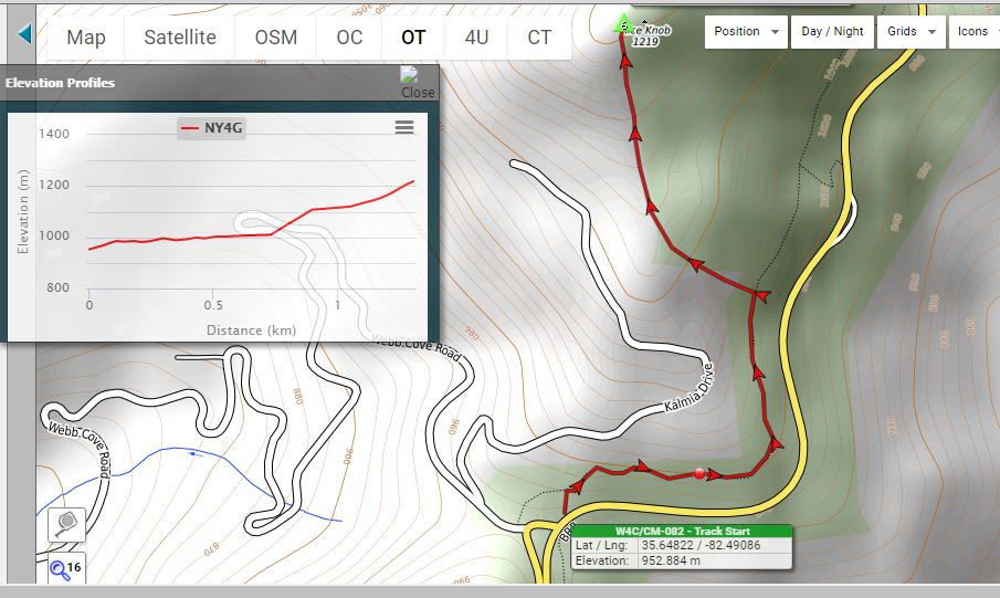
The hiking group went off trail to a shelter near the summit.   We proceeded on our trail on the AT and found the trail descending.   Scott paused.   This is not right, we should be going up.   The summit coordinates on the GPS is supposed to be 100 meters away pointing to our left and not along the trail line.   We concluded, the AT does not cross the summit.   We hiked back to where the other hikers entered a trail to the shelter and joined them there.  We were supposed to be at 1917m ASL at the summit and we were at 1910m at the shelter.  Clearly we were in the Activation Zone or the AZ.  We met the other hikers at the shelter and took photos of each other at the shelter.   Scott proceeded to walk another 50m or so away from where I was to set up his radio station.    I set up near the shelter.   The wind was still gusting around us but the trees provided a good wind break.  Still we could feel the chill.   My feedline was too short to allow me to operate in the shelter.  I picked a sunny spot to set up my 1 pound camp chair.   There was no cell service.  We could not send a spot to the SOTA spotting network thru the internet alerting our chasers that we were ready to make contact.   Being about noon, I went on the 20m band and started calling CQ.   The frequency that was published on the alert I had published earlier in the day was occupied by a couple of hams having a long conversation.   So I parked myself a few kilohertz below them at 14063 thinking that one may look for me there.  After calling CQ for about 10 minutes, a Canadian ham VE1WT called me.  We exchanged pleasantries and signal reports. 

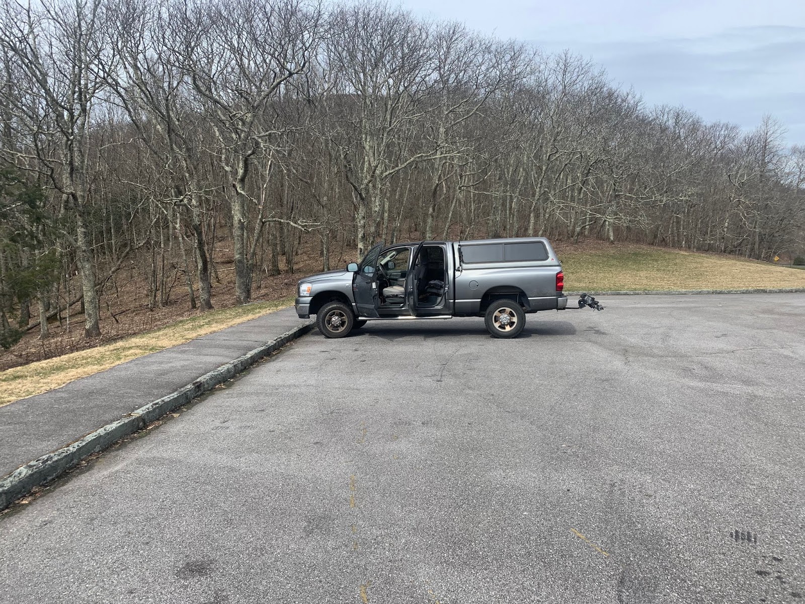
I politely asked him (in Morse) to spot me in the cluster.  I am not sure where he spotted, but I started getting calls.   Next was Jorge, EA2LU, a frequent chaser from Spain.  He came in really loud.   I knew he was a chaser, so I asked him to spot me on the SOTA cluster.   My mind must have had brain freeze.   My mind was still fixated that our first summit was Grassy Ridge Bald – and I gave him the wrong summit reference to post, W4C/EM-005.   We were actually in W4T/SU-005.   A wrong summit reference we can fix later.   We can always email our callers to correct their logs.   The callers kept coming and after about 10 minutes I had a dozen.  They were all familiar chaser calls except for the one from England.   This was a first for me to be chased by someone from the UK.  It was G4OBK, Philip Catterall.   I read in his QRZ.com page bio that he is in the ARRL Honor Roll (as one who has made contact with all 340 current DXCC entities) and the first SOTA activator to summit all 176 summits in the British Isles and to chase the same 176 summits from his home station.   It took him 10 years to do it.   He was HF contest champion in England for 5 years but most of his activity now is dedicated to SOTA.   Philip is #3 in the all-time activator score with over 3000 points from the G (England) Association.  I am sorry for digressing and now back to our Roan Knob experience.  Scott walked over to me.   His voice sounding desperate.  “Did you get any calls?” he asks.   I said “Yeah, I have about a dozen and I even have one from the UK”.   He asks, “Can I jump on your frequency, and make calls from there?  I only have one call and it is from David KF4DKW on 2m FM.   I have been calling CQ on 30m for 30 minutes without a single call”.   I said “Sure, let me tell my callers, to listen for you”.   I then got on the paddle and said in Morse “QRX, QRX, KW4JM WILL BE CALLING CQ NEXT PSE CALL HIM”.    As soon as I finished sending that message in Morse, I heard Scott, very loudly calling CQ, and started making contacts.   I got up, walked to the sunlit areas seeking warmth.   My fingers were numb despite gloves.  I then walked inside the shelter, thinking it would be warmer there.  No, it was better in the sunshine.   I removed my gloves and put them in my pants pocket hoping the body heat will thaw it.  All this time I can hear Scott making contacts even from 25 meters away as I was desperately trying to get warm.    I then later saw Scott walking to me saying “I am done! Let us get the hell off this mountain”.    Those were the very words I wanted to hear.  Without hesitation, inside of 5 minutes, I was packed and ready to go down that ice covered trail.  We reached the comfort of my truck in about 3 hours and 42 minutes from when we set out at the beginning.   We actually were on a good hiking pace of about 35 minutes a mile, despite all the ice.  We hiked 4.17 miles, and climbed 784 feet of vertical.   I record all my GPS tracks and upload it to a site called STRAVA so I can later study the hike statistics.


We sat in the truck contemplating our next move.   I said “So I guess we are not doing Grassy Ridge Bald today”.  Scott answered, “You could not pay me money to go up Grassy Ridge Bald under these conditions”.   I jokingly said “If I gave you a million dollars, would you go up Grassy Ridge Bald?”   Scott replied “For a million dollars, maybe I will do it, but I would not do it for a half million”.
Since Locust Bald is next, we proceeded down the road towards Locust Knob.   Fortunately, Scott had written down directions, since there was no cell service to activate Google Maps on the cell phone.  Locust Knob is a “drive-up”, a summit where one can drive all the way or very close to the summit.  It is invariably through a windy and steep road, with many switchbacks, often dirt or gravel covered, almost always narrow, and during rain, very treacherous.  We were lost for a while searching for the right roads, when all of a sudden, cell service came back and Google maps directed us to Bernie Lane, in Bakersfield NC.   We proceeded up the windy forest road and about 150 meters away from the summit, we saw two big posts with prominently placed purple paint and no-trespassing signs on it.  We hesitated and stopped for 20 minutes.  We texted Dean Blair K2JB who has activated Locust Knob before and asked if he has seen these no trespassing signs.  Dean had not seen this before, but had a more liberal interpretation of the “no trespassing signage” and still thought the summit was fair game.  We conversed that we still had Phillips Knob, another 6 pointer, as a backup and it was still early.  So we abandoned Locust Knob and proceeded to Philips Knob, which was not very far.

By the time we summited Philips Knob, another drive-up, the weather had changed to the mid-forties at the summit with calm winds.   The summit had wonderful views from the fire tower.  Celo Knob was very prominent on the southern horizon.  We set up our stations quickly and before too long, we were able to “sweep the bands” and make contacts with our chasers.   I was fortunate enough to make two summit-to-summit contacts with an activator in the Colorado Front Range on the summit of W0C/FR-064.   It was George KX0R.  He was very faint about a 1 or 2 on the signal strength on the 40 meter band but intelligible.   I asked him for his summit reference repeatedly just to be sure I had it right.    He called me again on a different band, 30m, and he was louder there perhaps a 4 or 5 on the strength scale.   I asked him if we was still on FR-064 and he answered yes.   Gary and Martha Auchard (W0MNA and W0ERI) from Kansas, are amongst our most loyal chasers, called us, as did Dean Blair K2JB, our friend. Amongst those who called me are also Paula, K9IR, from Illinois, Karen K4KRN from Tennessee, and “Super Sloth” Bruce W2SE.   (Super Sloth is a designation given to a chaser with 10000 chase points).

On the trip down, we conversed about the salvage operation we did that day, abandoning both Grassy Ridge Bald and Locust Knob, which were on the original plan.   Thanks to Scott’s and Dean’s knowledge of the surrounding area, we still had a “Plan B” to resort to.  Scott and I drove down to Asheville where his wife Jeannette was patiently waiting to take Scott home.   The first words out of Scott’s mouth as he met his wife was “It was c-o-o-o-l-d and I am glad it is over!!.”

Lane Pinnacle Triple

On February 18, KW4JM and I hiked Lane Pinnacle.  We met at Craven Gap and then drove to the Lane Pinnacle Trailhead at Potato Fields pullout on the BRP.  I followed the notes made by KW4JM and made a track.  The hike is entirely along the ridge line with beautiful views.  I wanted to see if it lived up to the billing that Scott had been raving about.    I got there about 9:00 AM and we proceeded in Scott’s Honda Civic a few miles north on the parkway to where the Mountains to Sea Trail (MST) intersects the parkway at Potato Fields Gap.  From the parking area we walked south about 50 meters to where the trail intersection is.   Lane Pinnacle did not disappoint.   The MST was a nice though technical trail.   It is narrow at times to about a few feet across with sheer drops to the left of over 100 meters.    There are several openings in the trail, which even in the summer, there are breathtaking views to the east.   The trail has two summits on the way to Pinnacle.   The peak itself is very small and there we set up with our radios to make contacts with our chasers.   We took several photos with our phone cameras of the many views along the way.


The next stop is Rice Knob.  We drove back to Craven Gap which is where the trail head is.   I wanted to see if it lived up to the billing that Scott had been raving about.  I knew Rice Knob was a bushwhack off the Mountains to Sea Trail.  What I did not appreciate was how steep it was.   Scott had already done the bushwhack twice before and he was looking for the place on the trail where he started to the summit off-trail.  The trail had been pretty flat for the better part of a kilometer.   Somewhere between the ¾ and 1 kilometer point – we went off trail and used our GPS to find the ridge line.   


There are several pricey homes to our left and we stayed clear of the backyards of these homes.   From the start of the bushwhack – it was steep.   We had 500 plus meters of horizontal with 200 meters of vertical.  There were three sections, the first one was steep, the second is on the shallower ridge, and the third is the final assault to the summit. From 728m to 895m or so, it climbed 100m in 165m – 66% grade.   It was a relief to find the shallower ridge.  It was pretty flat for 150m.   We had just shy of 200m to the top.  It was visually very steep.  We had to climb another 190m – so it was near a whopping 90% grade.   I am very unstable on my feet going down and so I dreaded the eventual trip down this mountain.  The peak was very small and narrow and Scott and I were separated by about 25 meters when we set up our radios.   We made our usual radio contacts.   It was cold and windy but not as windy as Lane Pinnacle.   Though it was in the 50s in the valley, up on the peaks it was in the mid-thirties – Fahrenheit, that is.

The time came for the dreaded hike down.  It was just a matter of committing to it and setting one foot in front of the other.  We finally made it down to the trail – and I thought “What a sight for sore eyes”.   We hiked the remaining kilometer or so on relatively flat ground back to car.

Scott drove me to the summit of Peach Knob just a few minutes away which is at the site of a communications tower.  Scott drove off and called me on the 2 meter hand held transceiver to score a chase. It took me all of 5 minutes to set up and another 10 minutes to make contacts with my chasers.   Radio interference from the tower cut me short – but the required contacts (four at least) had been made to score the mountain. 

Valentines Day Quadruple Activation

The thought of doing a quadruple entered my mind when I realized it was one of those weeks in the winter where the only sunny day is expected at a time when I had to do it alone, no Scott KW4JM and no Dave KE4EA.   Scott had a commitment to provide care for his aging parents and Dave had a commitment to lead a bible study.   Incidentally, I am also part of the same bible study group that Dave leads, but I had the luxury to skip this one.  I had several choices of summits in short open section of the Blue Ridge Parkway near Asheville NC – Mt. Pisgah, Mt. Hardy, Black Balsam, Green Knob, Rough Butt Bald, Richland Balsam and Steestachee Bald – and I had to pick the easiest 4.   I knew Pisgah was hard.  I had been there.  It was 2 km with 358m of vertical – so Pisgah is out.   Black Balsam is a popular hiking spot though I had never hiked it.  It seemed promising.   Black Balsam is in.  I had been wanting to hike Green Knob (CM-023) for a while.  It had good reviews from fellow activators.  Green Knob is in.   I had hiked Richland Balsam before in the fall of 2018 and I remembered it being pretty easy.   Richland Balsam is in.   The remaining three are bushwhacks.   I don’t like bushwhacks.  I don’t mind them when I am with Scott as Scott is my “security blanket” when it comes to bushwhacks.   He is not afraid of them and seems to relish them.  But I had to pick one and I picked Rough Butt Bald based on its proximity to the other three.   Rough Butt Bald did not have any good press – Barry N1EU had a rough time (no pun intended) approaching it from the eastern part of the ridge.  Even Patrick KI4SVM called it “not so bad when you approach it from the left side of the ridge”.  What I had to look forward to where thorns and briars all over the open portions of the ridge.

Green Knob WM-023 was easy, not a “cakewalk”.  The trail is the MST climbing a narrow ridge.  There were many nice views through the leafless trees.  There were some pines and some rhododendrons.  I set up my antenna on the narrow ridge as an inverted V with both legs along the ridge.   I had one of my Spanish chasers Jorge EA2LU call me along with stateside chasers.  By 11 AM I was already on my way to Black Balsam.   When I got to Black Balsam, I had a choice of two trails, the upper Art Loeb spur or the lower main Art Loeb trail.   In hindsight, I picked the wrong one.    The upper trail is below the tree line.  The trail is cut like a narrow ditch, covered with rocks and sheltered from the sun by the trees.  Water had collected at significant portions of the trail and the trail was covered in ice. I had to pick my steps from rock to rock to not step on the ice.   There was this section where there were no rocks to step on.   For about 25 meters, I had to use my trekking poles for balance to keep from falling as I very slowly negotiated that portion of the trail.   I finally got above the tree line and the trail was so much better.  The summit of Black Balsam was large and open with stunning views for a full 360 degree panorama of the nearby mountains – no wonder it is so popular.   I lingered up on the summit for about an hour.  It was windy and cold.  I made my radio contacts and proceeded to hike down.   There was this black girl who was also there sheltered in the rocks from the wind.  As I was walking down the trail, I had noticed that she had gotten up and started to come down as well.   I waited for her and we hiked down the mountain and talked together for a bit.  It turns out she wants to become a forest ranger and she is hiking alone for the day for about 8 miles.  She took the main Art Loeb trail and we hiked down together this rock covered trail above the tree line.  There was no ice anywhere on this trail.  I got to the road and knew I still had 500 meters or so to hike back to the truck.   The second of the four summits was complete.

I proceeded to Rough Butt Bald just a few kilometers from Black Balsam on the BRP to a pullout at Bearpen Gap.   I re-read the description that Patrick KI4SVM had written and found the MST on the north side of the parking area.   I followed Patrick’s suggestion to approach it from the left.   There were some large fallen trees on the left side and I had to skirt them by either wandering to the open areas on the right covered in briars and to left into the steep side of the ridge. After much zigzagging up the ridge, I entered the “activation zone” which is the area 25m of vertical or less from the summit proper.   I did not go into the very summit.  There were thorny areas on the way there and I did not need to do it.  I made my required radio contacts and proceeded back down.  

It was about 4 pm when I arrived at Richland Balsam’s trailhead.   I should have stuck to what I knew was easy.  But no, I had to pick the lower trail just to be different.   On the bright side, there is a nice opening for a good view for photos on the lower trail.   On the not so bright side, I slipped and fell on one of the ice covered sections and slammed my elbow into the rocks.   The bruise has since healed.   I took the known “nice upper trail” on the way back to the parking spot.  I also had the nice bonus of a call from my Australian chaser VK4TJ.   I probably had about 30 minutes of daylight once I got back in the truck.   I lingered there for about 10 minutes relishing the day’s accomplishments – 4 summits and 50 activator points.  I began to wonder.  Is this some kind of record for the W4C association?  Dean Blair K2JB later confirmed that it is.   Quadruples are relatively rare and all the previous ones were done before winter.   I was the only one to have done it in the winter months.   
The previous record was 42 points for 5 summits by K2JB himself.

Sequence and Logistics:

First stop is Green Knob W4C/CM-023.  The trail notes from prior activators are pretty good.  I drove to my QTH to Blue Ridge Parkway MM412.5   I had to park on the shoulder precisely at the coordinates specified by WH6LE which is approaching it from the north east.

Park on the east shoulder and cross the road into the Mountains to Sea Trail.  It is an easy hike on a nice trail with good views.   The entire trail is on the ridge.


The next is Black Balsam by driving to the BRP MM420.2 and making a turn into the road to the Art Loeb trail heads.   There are two trailheads, the upper with a privy and the lower one on the right side parking area.   I made the mistake of using the upper trail this day.  On a summer day, this one is better because it is below the tree line with plenty of shade but this is winter and we had a lot of rain and the rain froze on the trail as ice.   It made negotiating this upper trail treacherous.   Great views once you get above the tree line.  There are no trees on the summit so you need a mast.


Third stop is Rough Butt Bald.   This is appropriately named summit.   Drove to the Bear Pen overlook and looked for the MST on the north side of the parking area.  Enter the MST for a few yards and then immediately head upthe ridge.  You will do a lot of zigging and zagging as you avoid obstacles.   This is a real bush whack through the ridge.  In hind sight, probably should have brought a machete. There are plenty of briars and thorns on the open areas.   KI4SVM suggested attacking it from the side of the left ridge which is what I did to avoid the thorny areas.  I set up once I reached the AZ..


Last stop is Richland Balsam.  I drove to the Overlook at MM 431 and I followed the track below.  In hindsight I would have followed the upper trail and not made a loop.  The lower trail had sections which were ice covered.  I started on the lower trail and made a big loop.