Friday, March 1, 2019

Lane Pinnacle Triple

On February 18, KW4JM and I hiked Lane Pinnacle.  We met at Craven Gap and then drove to the Lane Pinnacle Trailhead at Potato Fields pullout on the BRP.  I followed the notes made by KW4JM and made a track.  The hike is entirely along the ridge line with beautiful views.  I wanted to see if it lived up to the billing that Scott had been raving about.    I got there about 9:00 AM and we proceeded in Scott’s Honda Civic a few miles north on the parkway to where the Mountains to Sea Trail (MST) intersects the parkway at Potato Fields Gap.  From the parking area we walked south about 50 meters to where the trail intersection is.   Lane Pinnacle did not disappoint.   The MST was a nice though technical trail.   It is narrow at times to about a few feet across with sheer drops to the left of over 100 meters.    There are several openings in the trail, which even in the summer, there are breathtaking views to the east.   The trail has two summits on the way to Pinnacle.   The peak itself is very small and there we set up with our radios to make contacts with our chasers.   We took several photos with our phone cameras of the many views along the way.


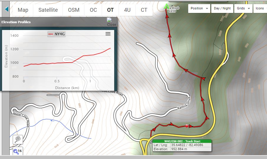
The next stop is Rice Knob.  We drove back to Craven Gap which is where the trail head is.   I wanted to see if it lived up to the billing that Scott had been raving about.  I knew Rice Knob was a bushwhack off the Mountains to Sea Trail.  What I did not appreciate was how steep it was.   Scott had already done the bushwhack twice before and he was looking for the place on the trail where he started to the summit off-trail.  The trail had been pretty flat for the better part of a kilometer.   Somewhere between the ¾ and 1 kilometer point – we went off trail and used our GPS to find the ridge line.   


There are several pricey homes to our left and we stayed clear of the backyards of these homes.   From the start of the bushwhack – it was steep.   We had 500 plus meters of horizontal with 200 meters of vertical.  There were three sections, the first one was steep, the second is on the shallower ridge, and the third is the final assault to the summit. From 728m to 895m or so, it climbed 100m in 165m – 66% grade.   It was a relief to find the shallower ridge.  It was pretty flat for 150m.   We had just shy of 200m to the top.  It was visually very steep.  We had to climb another 190m – so it was near a whopping 90% grade.   I am very unstable on my feet going down and so I dreaded the eventual trip down this mountain.  The peak was very small and narrow and Scott and I were separated by about 25 meters when we set up our radios.   We made our usual radio contacts.   It was cold and windy but not as windy as Lane Pinnacle.   Though it was in the 50s in the valley, up on the peaks it was in the mid-thirties – Fahrenheit, that is.

The time came for the dreaded hike down.  It was just a matter of committing to it and setting one foot in front of the other.  We finally made it down to the trail – and I thought “What a sight for sore eyes”.   We hiked the remaining kilometer or so on relatively flat ground back to car.

Scott drove me to the summit of Peach Knob just a few minutes away which is at the site of a communications tower.  Scott drove off and called me on the 2 meter hand held transceiver to score a chase. It took me all of 5 minutes to set up and another 10 minutes to make contacts with my chasers.   Radio interference from the tower cut me short – but the required contacts (four at least) had been made to score the mountain. 

Valentines Day Quadruple Activation

The thought of doing a quadruple entered my mind when I realized it was one of those weeks in the winter where the only sunny day is expected at a time when I had to do it alone, no Scott KW4JM and no Dave KE4EA.   Scott had a commitment to provide care for his aging parents and Dave had a commitment to lead a bible study.   Incidentally, I am also part of the same bible study group that Dave leads, but I had the luxury to skip this one.  I had several choices of summits in short open section of the Blue Ridge Parkway near Asheville NC – Mt. Pisgah, Mt. Hardy, Black Balsam, Green Knob, Rough Butt Bald, Richland Balsam and Steestachee Bald – and I had to pick the easiest 4.   I knew Pisgah was hard.  I had been there.  It was 2 km with 358m of vertical – so Pisgah is out.   Black Balsam is a popular hiking spot though I had never hiked it.  It seemed promising.   Black Balsam is in.  I had been wanting to hike Green Knob (CM-023) for a while.  It had good reviews from fellow activators.  Green Knob is in.   I had hiked Richland Balsam before in the fall of 2018 and I remembered it being pretty easy.   Richland Balsam is in.   The remaining three are bushwhacks.   I don’t like bushwhacks.  I don’t mind them when I am with Scott as Scott is my “security blanket” when it comes to bushwhacks.   He is not afraid of them and seems to relish them.  But I had to pick one and I picked Rough Butt Bald based on its proximity to the other three.   Rough Butt Bald did not have any good press – Barry N1EU had a rough time (no pun intended) approaching it from the eastern part of the ridge.  Even Patrick KI4SVM called it “not so bad when you approach it from the left side of the ridge”.  What I had to look forward to where thorns and briars all over the open portions of the ridge.

Green Knob WM-023 was easy, not a “cakewalk”.  The trail is the MST climbing a narrow ridge.  There were many nice views through the leafless trees.  There were some pines and some rhododendrons.  I set up my antenna on the narrow ridge as an inverted V with both legs along the ridge.   I had one of my Spanish chasers Jorge EA2LU call me along with stateside chasers.  By 11 AM I was already on my way to Black Balsam.   When I got to Black Balsam, I had a choice of two trails, the upper Art Loeb spur or the lower main Art Loeb trail.   In hindsight, I picked the wrong one.    The upper trail is below the tree line.  The trail is cut like a narrow ditch, covered with rocks and sheltered from the sun by the trees.  Water had collected at significant portions of the trail and the trail was covered in ice. I had to pick my steps from rock to rock to not step on the ice.   There was this section where there were no rocks to step on.   For about 25 meters, I had to use my trekking poles for balance to keep from falling as I very slowly negotiated that portion of the trail.   I finally got above the tree line and the trail was so much better.  The summit of Black Balsam was large and open with stunning views for a full 360 degree panorama of the nearby mountains – no wonder it is so popular.   I lingered up on the summit for about an hour.  It was windy and cold.  I made my radio contacts and proceeded to hike down.   There was this black girl who was also there sheltered in the rocks from the wind.  As I was walking down the trail, I had noticed that she had gotten up and started to come down as well.   I waited for her and we hiked down the mountain and talked together for a bit.  It turns out she wants to become a forest ranger and she is hiking alone for the day for about 8 miles.  She took the main Art Loeb trail and we hiked down together this rock covered trail above the tree line.  There was no ice anywhere on this trail.  I got to the road and knew I still had 500 meters or so to hike back to the truck.   The second of the four summits was complete.

I proceeded to Rough Butt Bald just a few kilometers from Black Balsam on the BRP to a pullout at Bearpen Gap.   I re-read the description that Patrick KI4SVM had written and found the MST on the north side of the parking area.   I followed Patrick’s suggestion to approach it from the left.   There were some large fallen trees on the left side and I had to skirt them by either wandering to the open areas on the right covered in briars and to left into the steep side of the ridge. After much zigzagging up the ridge, I entered the “activation zone” which is the area 25m of vertical or less from the summit proper.   I did not go into the very summit.  There were thorny areas on the way there and I did not need to do it.  I made my required radio contacts and proceeded back down.  

It was about 4 pm when I arrived at Richland Balsam’s trailhead.   I should have stuck to what I knew was easy.  But no, I had to pick the lower trail just to be different.   On the bright side, there is a nice opening for a good view for photos on the lower trail.   On the not so bright side, I slipped and fell on one of the ice covered sections and slammed my elbow into the rocks.   The bruise has since healed.   I took the known “nice upper trail” on the way back to the parking spot.  I also had the nice bonus of a call from my Australian chaser VK4TJ.   I probably had about 30 minutes of daylight once I got back in the truck.   I lingered there for about 10 minutes relishing the day’s accomplishments – 4 summits and 50 activator points.  I began to wonder.  Is this some kind of record for the W4C association?  Dean Blair K2JB later confirmed that it is.   Quadruples are relatively rare and all the previous ones were done before winter.   I was the only one to have done it in the winter months.   
The previous record was 42 points for 5 summits by K2JB himself.

Sequence and Logistics:

First stop is Green Knob W4C/CM-023.  The trail notes from prior activators are pretty good.  I drove to my QTH to Blue Ridge Parkway MM412.5   I had to park on the shoulder precisely at the coordinates specified by WH6LE which is approaching it from the north east.

Park on the east shoulder and cross the road into the Mountains to Sea Trail.  It is an easy hike on a nice trail with good views.   The entire trail is on the ridge.


The next is Black Balsam by driving to the BRP MM420.2 and making a turn into the road to the Art Loeb trail heads.   There are two trailheads, the upper with a privy and the lower one on the right side parking area.   I made the mistake of using the upper trail this day.  On a summer day, this one is better because it is below the tree line with plenty of shade but this is winter and we had a lot of rain and the rain froze on the trail as ice.   It made negotiating this upper trail treacherous.   Great views once you get above the tree line.  There are no trees on the summit so you need a mast.


Third stop is Rough Butt Bald.   This is appropriately named summit.   Drove to the Bear Pen overlook and looked for the MST on the north side of the parking area.  Enter the MST for a few yards and then immediately head upthe ridge.  You will do a lot of zigging and zagging as you avoid obstacles.   This is a real bush whack through the ridge.  In hind sight, probably should have brought a machete. There are plenty of briars and thorns on the open areas.   KI4SVM suggested attacking it from the side of the left ridge which is what I did to avoid the thorny areas.  I set up once I reached the AZ..


Last stop is Richland Balsam.  I drove to the Overlook at MM 431 and I followed the track below.  In hindsight I would have followed the upper trail and not made a loop.  The lower trail had sections which were ice covered.  I started on the lower trail and made a big loop.


Wednesday, February 20, 2019

Siler Bald - Wesser Bald Doubleheader

After two failed attempts at Siler Bald, we (Scott and I) finally made it on February 7, 2019.   The 1st was last year - during an attempted doubleheader with Wine Spring - we were only able to do Wine Spring because it started raining too hard.  The second one was a few weeks ago when we tried the same double - this time - yet again - only Wine Spring because the forest road gate was closed and we had to hike the forest road.


We were on the Appalachian Trail (AT) for most of the hike - then we went off trail to head to the summit.


Here is Scott KW4JM - on the AT


Here I am at the same point on the AT


The off trail hike was on a very wide and open ridge to the summit of Siler Bald


Here is the monument at Siler Bald summit - to prove I was there


Being that we are just off the AT by a few hundred yards - this family joined us at the summit.   The kids heard Morse code for the very first time.


The sun finally peaked through and the cloud cover unraveled the beautiful view

The second half of the day is the hike to Wesser Bald.   Weser Bald trailhead is but a short drive from the Siler Bald trailhead on Wayah Rd.  We went north on Wayah Rd and then a right turn at Otter Creek Rd which takes us to the Wesser Bald trailhead.


Here we are approaching the observation deck at the summit.  It is a rebuilt fire tower on a steel frame.


The views from the observation deck were spectacular


Showing a seemingly endless sea of mountains


Wednesday, February 6, 2019

Shumont Mtn - Bear Wallow Mtn Doubleheader

This was another late day outing.  KW4JM and I met at the Post Office in Bat Cave and proceeded to park at a nearby Baptist Church.   We took the 4WD to Shumont.   The parking area requires a permit to have access (gate is a combination lock accessible to open by permit holders).   The trail leading to the parking area after the gate is a rough gravel road.  Once at the trailhead, the trail first leads to Eagle Rock to the left - and so we took in the views from Eagle Rock.  We then proceeded to the junction and made the right turn off the Eagle Rock spur to Shumont.   The trail along the ridge is nice and wide.  The summit comes to a small peak with very small area for two activators.   To avoid interference - one should set up a little further down in the AZ.


A 360 degree view movie at the summit of Shumont Mountain


The gate - go through this gate to get into the parking area.


Our first stop was Eagle Rock for photos.  Here is KW4JM


The view from Eagle Rock


That is the view with the Shumont peak in the background


Me - at Eagle Rock


A view of Lake Lure in the distance


Another view of Lake Lure from the summit of Shumont


Operating position at the Shumont Peak


A surprise contact from ZL1BYZ


It is only about a 3 mile drive to the Bearwallow trailhead.  There are a couple of options once you reach the trailhead - hike the trail or hike the fire road.   We chose the latter as it is easier both up and down.   The distance is about the same.  The summit is both large and open with plenty of space for multiple activators.


The gravel road leading up to the summit


Ice and snow along the trail


Antenna farm at the summit


Another contact with a chaser from New Zealand ZL1BYZ


W4C/CM-016 Walker Bald

A late day outing - we (KW4JM and I) met at Home Depot off US74 and then drove to Maggie Valley to the Ski Resort of Cataloochie Farm.  We asked one of the homeowners for permission as the gate is closed with purple paint (no trespassing).   We got our permission and crossed over the barbed wire fence.  The most eventful portion of the hike is the pants leg getting caught in a barb. Also the road to the trail head at Triple Gate road would do well with a 4WD vehicle.  The trail is a beautiful and well marked by previous hikers with various color blazes.

There were plenty of areas to set up at the summit and the views were beautiful.  The hike was short - 1 km with modest vertical.


More pictures to follow:

More than just one summit in a single day?

The following are categorized as either home runs, tripleheaders or doubleheaders.   In my short career as an activator - I have yet to do more than two per day.   But based on experience, namely that of K4KPK (Kevin Kleinfelder) and that of KW4JM (Scott Carter) and also my own thinking, I think three and even 4 are possible.   K4KPK probably has done most of the list below as it is a conglomeration of his favorites and my ideas of what is possible.   This list will get updated over time.  The ones in bold are the ones I have already done.

Home Runs (4 Summits in One Day)

  • W4C - Western Mountains:  Mt Hardy (10), Rough Butt (10) Richland Balsam (10) and Steestachee (10) High Country: Dyer Mountain (8), Flat Top Mountain (4WD required) (8), Cowpen Mountain (10), Bald Mountain (10)- 52 points with Winter Bonus.  Right now doable with that section of the BRP Open
  • W4C - Western Mountains:  Richland (10), Steestachee, Barnett (8), Waterrock (10). Possible only if the BRP is open past MM 436 - after the BRP opens that section 38 pts (no winter bonus)
Tripleheader (3 Summits in One Day)
  • W4C Central: Black Balsam (10), Green Knob (CM-023) (8), Mt Pisgah (10) - 28 points
  • W4C Central: Mt. Mitchell (10), Green Knob (CM-020) (8), Craggy Dome (10) - 28 points
  • W4G North Georgia: Brasstown Bald, Bell Knob, Ravencliff Bald (28 pts)
  • W4G HC: Dyer, Cowpen, Bald (28 pts)
  • W4C WM: Clingman’s Dome, Nettle Creek Bald, Barnett Knob (26 pts)
  • W4C WM: Clingman’s Dome, Nettle Creek Bald, Cowee (28 pts)
  • W4C WM: Winespring, Siler, Wesser (26 pts) - before December 15 FS closes
  • W4G NG: Rabun Bald, Blackrock Mtn, Bell Knob
  • W4C WM: Richland, Waterrock, Barnett (28 pts)
  • W4G NG: Rocky Mountain (W4G/NG-011), Blue Mountain, Wildcat (28 pts)
  • W4C WM: Shortoff Mtn, Yellow Mtn, Whiteside Mtn (24 pts)
  • W4C WM:  Huckleberry, Stratton, Hemlock
  • W4G HG: Brasstown, Ravencliff, Bell Knob or Glassy Mtn
  • W4C US: Sassafras, Pinnacle, Table Rock (12 pts plus 9 bonus if done in winter - using a one way hike through 3 summits mostly downhill)
Doubleheaders (2 Summits in One Day)
  • Shumont, Bearwallow (16 pts)
  • Winespring, Siler 
  • Winespring, North Eaglenest (18 pts)
  • Walker Bald, North Eaglenest (18 pts)
  • Rocky Mtn, Tray Mtn (20 pts)
  • Blue Mountain, Brasstown Bald (20 pts)
  • Shortoff, Yellow (16 pts)
  • Siler, Wesser (16 pts)
  • Blood Mtn, Coosa Mtn (20 pts)
  • Richland, Waterrock (20 pts)
  • Clingman's Dome, Nettle Creek Bald (18 pts)